#TCRNo06 #TCR06cap36
You are now at post 05c of my TCR series. If you wish to read them in order and/or first want to find out what this is all about.., voilà:
01 Next BIG thing: The Transcontinental Race – I’m Cap 36
02 TCR06 – Preparation
03 TCR06 – Hopes, Motivation & Fears (3 lists)
04 TCR06 – Finished!
05a TCR06 – Visual Race Report – 1. Introduction
05b TCR06 – Visual Race Report – 2. Timeline Overview
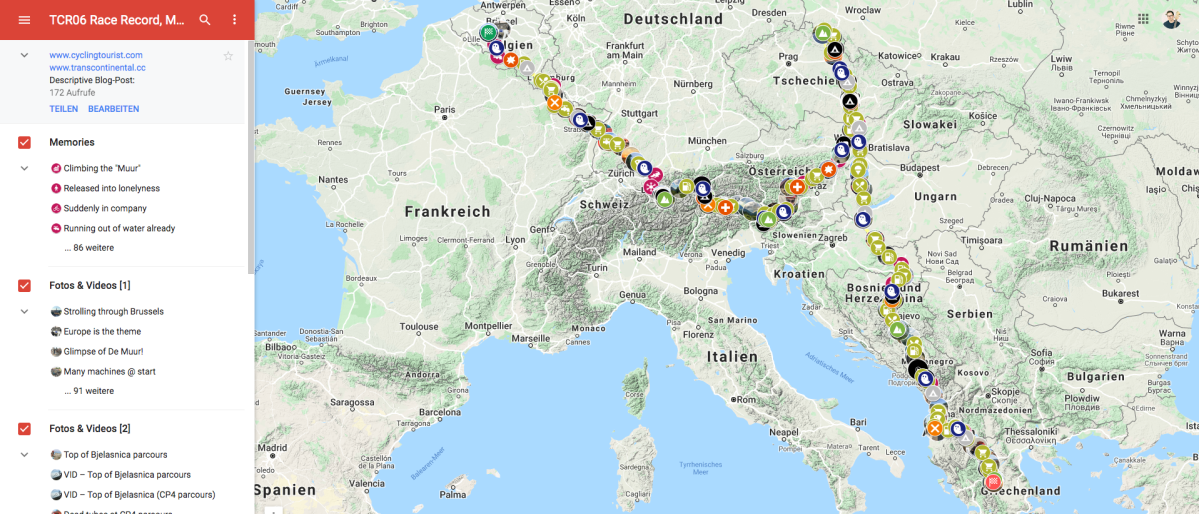
05c TCR06 – Visual Race Report – 3. Interactive Map
CLICK HERE to get straight to the Interactive Map.
! open on desktop ! (not phone)
A few words on how to use the map
Firstly: the map only really works on Desktop; to benefit from all the features I built in and for comfortable usability, you need a proper screen and mouse/touchpad (i.e.: mostly useless on your smartphone).
The interactive map lets you dive into alllll the details of my Transcontinental Race in 2018 (edition 06). Additionally it’s of course possible to copy-paste GPS coordinates of specific spots/pictures/momories/etc. from my map into GoogleMaps to check them on Streetview. In case you’d really want to go all the way (which I doubt) you could even use multiple browser tabs simultaneously, e.g.: Timeline, MyMap-Racemap, GoogleMaps.
Layers of the map (switch on/off)
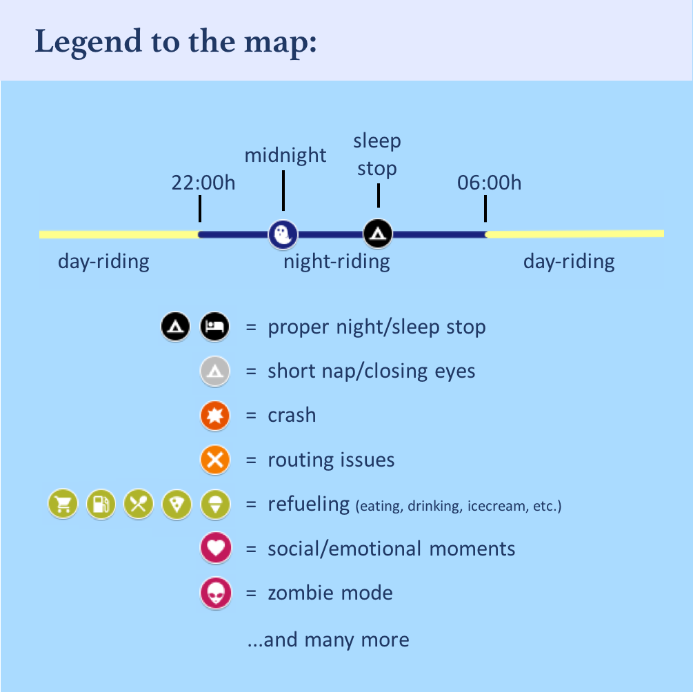
The geo-points are divided into layers that can be displayed or hidden on the left. You can click on each item in one layer to get to the respective point. Check the map-legend below. There’s occasionally a bit of text to read behind each point:
 GPS-track:
In order to show where I cycled in daylight and at night, the track is coloured yellow from 06:00-22:00h (day) and dark blue from 22:00-06:00h. It very roughly matches sunrise and sunset.- Midnights & Mountains:
In order to really see what section I rode on what calendar day, I created markers for all the spots I passed at exactly midnight, and also numbered them by the race day that would begin with it. As landmarks I also included mountains. However because they obscure some of the day/night-colour coding, I put those into a separate layer to allow you and me to switch them off, too. So you can switch off everything except for the route to get the most basic overview. - Sleep:
Here you find in black all the spots where I had what I’d call a proper night rest, i.e. where I pulled out my sleeping mat to try to really sleep, or where I booked a bed somewhere (which happened twice). In light grey you find those spots where I closed my eyes for a bit. Sometimes some of that was sleep, but mostly it was just lying down on my back and relaxing. So next to going from midnight to midnight to see calendar days, you can alternatively go from black tent to black tent to see the beginnings and ends of separate stints (“stint” defined as the part of the way between two proper night rests). - Memories:
These are random memories. They may address anything: detailed stories about my mood & things I experienced, struggles I had, people I met, etc. If you’re going for the story-telling part, this is where to look. Usually they also contain a text description of the situation. - 2 Photo-Layers:
They are sorted chronologically in the list. (There is no functional, just a technical reason for having two layers) - Refueling:
Those are all stops that I identified as stops where I bought food or drinks. These are by far not complete: There must have been many more. But the displayed amount already gives you an impression how central eating is to the race. - Adversities:
These include multiple crashes, their stories, reasons and impact. Furthermore routing problems and health issues.
Method: Reconstructing memories after 1,5 years?
First of all: Yes, it was all long ago, but it also was such an intense and memorable experience that many moments, places, etc. are still burnt into my memory. Still: I got myself some help in the form of bits and bytes: downloaded and organized my GPX-files, i.e. the GPS-tracks that I recorded with my Wahoo Elemnt GPS unit. It plotted one GPS point per second of riding. Additionally, I had set it to auto-pause during TCR, so anytime I did not move for longer than 5 seconds, there is a gap in the record.
I followed essentially these 6 steps:
- Downloading the GPX files
- cutting up and converting the files in several ways (e.g. by calendar day and stage)
- creating excel functions to better find the gaps in the record and thereby tracing every single time I stopped
- check the respective GPS coordinates of each break longer than 30 seconds on GoogleMaps incl. StreetView and thereby remember what exactly was going on.
- Create a note in my interactive map, choose an icon, picture and some text
- Sort all points chronologically in the layer-list, per layer
Yes, it was a lot of work. In the process of that I also began to recall many more moments and memories in the context of those breaks so that in the end I had a VERY detailed account of all the stuff that happened to me during those 14,5 days. Of course that way I also figured out how long I rode each day in terms of time and km/elevation, and how long and where I stopped to get some night rest (when I did); i.e. the beginnings and ends of the separate stages
Below you find the map, but I highly recommend to open it in a new tab with this link.
-> INTERACTIVE MAP (link)

OMG – how many crashes? Maybe a more regular sleep routine would work for you. I kept a strict day/night timetable and never once felt sleepy on the bike.
Interesting way to tell your story, certainly helped relate to the differences in our routes. I took shorter routes but with more climbing than you.
See you in Brest 🙂
LikeLiked by 1 person
hah, absolutely, Richard. That was my No1 lesson: proper sleep cycle. I already implemented it last year on TPBR. Definitely makes for less suffering and danger. That’s one reason for me to particularly look forward to this year’s edition!
And meeting you in Brest again, of course : )
LikeLike